Coastal Surface Geology of Washington State
Steven Eykelhoff & Richard C. Daniels
Department of Ecology,
Coastal Monitoring & Analysis Program
P.O. Box 47600
Olympia, WA 98504-7600

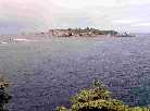
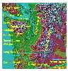 Map of Western Washington (USA) showing the location of coastal cities
and major geographic reference features.
Map of Western Washington (USA) showing the location of coastal cities
and major geographic reference features.
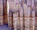
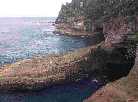 Sea caves formed in Pleistocene sandstone near Neah Bay, WA.
This area was glaciated as late as 6,000 years BP.
Sea caves formed in Pleistocene sandstone near Neah Bay, WA.
This area was glaciated as late as 6,000 years BP.
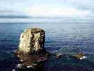
 Remnant of a former sea arch new La Push, WA. Composed of massive
Pleistocene sandstone on the older Hoh bedrock formation. The notched
area just above the high-tide level is a result of rapid weathering
due to repeated wetting and drying,
Remnant of a former sea arch new La Push, WA. Composed of massive
Pleistocene sandstone on the older Hoh bedrock formation. The notched
area just above the high-tide level is a result of rapid weathering
due to repeated wetting and drying,
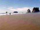 Needle and stack formations along the Olympic Peninsula coastline.
Note wide disapative beach indicating high wave energy.
Needle and stack formations along the Olympic Peninsula coastline.
Note wide disapative beach indicating high wave energy.
 Destruction (Lighthouse) Island near Kalaloch, WA. The island has a foundation
of steeply dipping sandstone strata of the Hoh bedrock formation.
About 50 feet of Pleistocene sand and gravel cap the uppermost part
of the island. This island is the western remnant of a broad glacial
outwash plain.
Destruction (Lighthouse) Island near Kalaloch, WA. The island has a foundation
of steeply dipping sandstone strata of the Hoh bedrock formation.
About 50 feet of Pleistocene sand and gravel cap the uppermost part
of the island. This island is the western remnant of a broad glacial
outwash plain.
 Sea stack at Point Grenville, just south of Taholah, WA. Composed
of volcanic material that was ejected onto the sea floor as lava some
45 to 50 million years ago. The lava has been incorporated with
existing sediments forming volcanic breccia.
Sea stack at Point Grenville, just south of Taholah, WA. Composed
of volcanic material that was ejected onto the sea floor as lava some
45 to 50 million years ago. The lava has been incorporated with
existing sediments forming volcanic breccia.
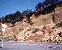 Ocean dipping unconsolidated Pleistocene outwash sediments south of
Taholah, WA. Erosion is from the weathering of the upper cliff face during
high wind events. Toe erosion occurs only during extreme winter storms.
Ocean dipping unconsolidated Pleistocene outwash sediments south of
Taholah, WA. Erosion is from the weathering of the upper cliff face during
high wind events. Toe erosion occurs only during extreme winter storms.
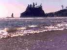
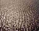 Sinuous crested current ripples in intertidal zone exposed during low tide
near Mukkaw Bay (La Push, WA).
Sinuous crested current ripples in intertidal zone exposed during low tide
near Mukkaw Bay (La Push, WA).
 Aeolian transport excavating current ripples during low tide near Long
Beach, WA (Fort Canby State Park).
Aeolian transport excavating current ripples during low tide near Long
Beach, WA (Fort Canby State Park).
 Interbeded unconsolidated sand layers at the entrance to a intertidal
marsh located near the mouth of Willapa Bay, WA (South of Westport, WA).
Interbeded unconsolidated sand layers at the entrance to a intertidal
marsh located near the mouth of Willapa Bay, WA (South of Westport, WA).
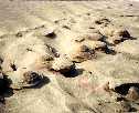
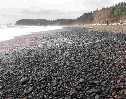 Reflective beach made up of cobbles north of La Push, WA.
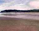 Dissipative beach made up of fine sand in Mukkah Bay (south of La Push, WA).
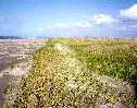 Dissipative beach made up of fine sand in Long Beach, WA. New
foredune is under development about 20-m seaward of the former primary dune.
Historically Southwest Washington derived its sand from the Columbia
River. Columbia River sands are found from Cannon Beach, OR to Taholah, WA.
Dissipative beach made up of fine sand in Long Beach, WA. New
foredune is under development about 20-m seaward of the former primary dune.
Historically Southwest Washington derived its sand from the Columbia
River. Columbia River sands are found from Cannon Beach, OR to Taholah, WA.
.
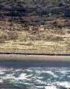 Dissipative beach in Long Beach, WA. Note the small erosion scarp formed
from the winter storms. The limited erosion is more than offset by
accretion within Long Beach, WA. This is demonstrated by the five former primary
dune lines than can be seen inland from the shore.
Dissipative beach in Long Beach, WA. Note the small erosion scarp formed
from the winter storms. The limited erosion is more than offset by
accretion within Long Beach, WA. This is demonstrated by the five former primary
dune lines than can be seen inland from the shore.
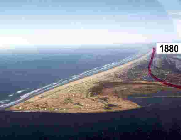 Massive accretion at Ocean Shores, WA. This region has experienced
annual accretion rates of 5 to 10 meters per year for the past 100 years
(note the 1880 shoreline in red). This accretion is in response to increased longshore
sand supply due to the construction of the Grays Harbor North Jetty from
1914 to 1919.
Massive accretion at Ocean Shores, WA. This region has experienced
annual accretion rates of 5 to 10 meters per year for the past 100 years
(note the 1880 shoreline in red). This accretion is in response to increased longshore
sand supply due to the construction of the Grays Harbor North Jetty from
1914 to 1919.
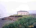
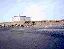 Coastal erosion just north of the Grays Harbor North Jetty in Ocean
Shores, WA in 1998. Erosion at this location prompted the construction of
a wave bumper (seawall) in front of this multi-million dollar structure.
Shoreline change analysis has determined that the land this building is
located on (see slide 15) did not exist in 1974.
Coastal erosion just north of the Grays Harbor North Jetty in Ocean
Shores, WA in 1998. Erosion at this location prompted the construction of
a wave bumper (seawall) in front of this multi-million dollar structure.
Shoreline change analysis has determined that the land this building is
located on (see slide 15) did not exist in 1974.
 Coastal erosion just north of the Grays Harbor North Jetty in Ocean
Shores, WA in May 1998. Note flanking erosion around the south side of the erosion
protection structure.
Coastal erosion just north of the Grays Harbor North Jetty in Ocean
Shores, WA in May 1998. Note flanking erosion around the south side of the erosion
protection structure.
 In this photo, taken 18 months later, the erosion had abated.
Note that the erosion scarp formed during the 1997/98 El Niño has been filled
and that the wave bumper is covered by drifting sand. This transition from
erosion to accretion is a systematic and natural cycle. If this variability had been estimated
it could have been used to develop building setbacks that would have limited
construction in the danger zone.
In this photo, taken 18 months later, the erosion had abated.
Note that the erosion scarp formed during the 1997/98 El Niño has been filled
and that the wave bumper is covered by drifting sand. This transition from
erosion to accretion is a systematic and natural cycle. If this variability had been estimated
it could have been used to develop building setbacks that would have limited
construction in the danger zone.
References
Komar, P. 1997. The Pacific Northwest Coast, Living with the Shores of Oregon and Washington. Duke University Press, Durham, NC
Orr, E.L. and W.N. Orr. 1996. Geology of the Pacific Northwest. McGraw-Hill Companies, Inc., New York, NY.
U.S. Geological Survey. 1978. Geology of Washington. Prepared by the U.S. Geological Survey in cooperation with
Washington Department of Conservation, Division of Mines and Geology. Department of Natural Resources, Olympia, WA.
Return to the Table of Contents